


How Did the Ice Age Create Rivers in North America?
The geological legacy of the Ice Age is evident across North America, with its majestic rivers winding through the continent like arteries that have carved their paths over millennia. But have you ever wondered how these rivers came into being? The answer lies in the fascinating interplay between ice and rock during the last glacial period. In this post, we’ll explore the question, “How did the Ice Age create rivers in North America?”, delving into the glacial processes and geological forces that shaped the waterways of today. Join us on a journey back in time to uncover the icy origins of North America’s greatest rivers.
The Last Glacial Maximum: Setting the Stage
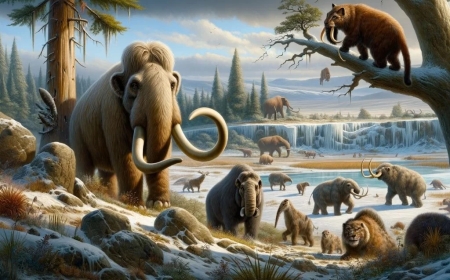
The story of how the Ice Age sculpted North America’s rivers began around 26,500 years ago, during the Last Glacial Maximum (LGM). At that time, a colossal ice sheet known as the Laurentide Ice Sheet covered much of present-day Canada and the northern United States, extending as far south as present-day New York City and the Ohio River Valley.
This vast ice sheet, measuring over two miles thick in some places, exerted immense pressure on the land beneath it. The glaciers moved slowly but relentlessly, grinding away at the bedrock and shaping the landscape in profound ways. In particular, the ice sheet created deep glacial valleys and expansive basins that would later serve as channels and reservoirs for North America’s rivers. As the glaciers advanced and retreated, they left behind an intricate network of moraines, outwash plains, and other landforms that would ultimately dictate the paths of rivers.
Meanwhile, the immense weight of the ice compressed the Earth’s crust, creating depressions that filled with water as the ice melted, forming massive lakes like Glacial Lake Agassiz and Glacial Lake Missoula. These lakes would later play a critical role in shaping river systems, as their sudden drainage caused catastrophic floods that carved new channels and reshaped existing ones.
Glacial Meltwater and Proglacial Lakes
One of the most significant ways in which the Ice Age influenced North America’s rivers was through the release of glacial meltwater. As the climate warmed and the glaciers began to recede around 20,000 years ago, they released vast quantities of water into the landscape. This meltwater pooled in depressions near the glacier fronts, forming proglacial lakes. Some of the most notable proglacial lakes of the period include Glacial Lake Missoula in present-day Montana and Glacial Lake Agassiz in what is now central Canada.
The presence of these proglacial lakes drastically altered the regional hydrology. For instance, Glacial Lake Missoula was impounded by an ice dam that periodically broke, releasing immense floods known as the Missoula Floods. These floods scoured the Columbia River Gorge, creating the Channeled Scablands and drastically altering the Columbia River’s course.
Similarly, the catastrophic drainage of Glacial Lake Agassiz reshaped the Mississippi River system, sending torrents of water down its tributaries and forming new channels like the Minnesota River Valley. The meltwater from these proglacial lakes also contributed to the formation of large river valleys and deltas, leaving behind fertile alluvial plains that continue to sustain agriculture today.
Glacial Erosion and the Carving of Valleys
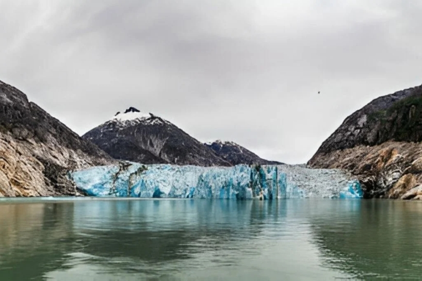
Glaciers are powerful agents of erosion, capable of carving deep U-shaped valleys that differ from the V-shaped valleys typically created by rivers. As glaciers advanced and retreated across North America, they scoured the bedrock, creating fjords, hanging valleys, and cirques that still shape the continent’s topography.
For instance, the glaciers that once covered the Great Lakes region excavated deep basins that later filled with water to form the modern-day Great Lakes. These basins also became channels for the major rivers draining the region, such as the St. Lawrence River, which flows from Lake Ontario to the Atlantic Ocean.
Further west, in the mountainous regions of the Rockies and the Sierra Nevada, glaciers carved out spectacular valleys like the Snake River Valley and the Yosemite Valley. In many cases, these valleys became home to rivers that still flow through them today, including the Snake River and the Merced River. In the Pacific Northwest, glacial erosion helped create the Puget Sound and influenced the paths of rivers like the Columbia and Skagit.
The retreating glaciers also left behind distinctive landforms like kettle lakes, eskers, and drumlins, which influenced river courses. For instance, the Des Moines Lobe of the Laurentide Ice Sheet left behind an array of kettle lakes and moraines that directed the flow of the Des Moines River in Iowa.
Outwash Plains and Braided Rivers
Beyond erosion, glaciers also played a key role in depositing sediments that shaped river systems. As the glaciers melted, they released a mixture of sand, gravel, and silt known as glacial outwash. This sediment accumulated in outwash plains beyond the glacier margins, forming broad, flat areas that rivers would later traverse.
Rivers flowing across these outwash plains often assumed a braided pattern due to the high sediment load and fluctuating discharge from glacial meltwater. Braided rivers typically consist of multiple interconnected channels that shift over time, creating a complex network of waterways.
One of the best-known examples of this phenomenon is the Saskatchewan River system in Canada. The North and South Saskatchewan Rivers originate from glaciers in the Rocky Mountains and flow across vast outwash plains before forming the Saskatchewan River. The retreat of the Laurentide Ice Sheet heavily influenced the region’s braided rivers and outwash plains.
In the United States, the Platte River in Nebraska and the Yellowstone River in Montana also display characteristics of glacially influenced braided rivers. Their broad floodplains and multiple channels testify to the immense quantities of meltwater that once flowed through them.
Legacy of the Ice Age: Modern River Systems
The impact of the Ice Age on North America’s rivers remains evident to this day. Many of the continent’s largest rivers owe their paths to the glacial processes of the last ice age. The Mississippi River, for instance, follows a course largely dictated by the retreat of the Laurentide Ice Sheet and the drainage of Glacial Lake Agassiz.
Similarly, the Great Lakes-St. The Lawrence River system is a direct result of glacial erosion and meltwater drainage. The St. Lawrence River continues to be a major conduit for the outflow of the Great Lakes, providing a critical link between the interior of North America and the Atlantic Ocean.
The Columbia River, which carved the Columbia River Gorge during the Missoula Floods, remains a key feature of the Pacific Northwest’s hydrology. Its dramatic gorge and powerful flow are testaments to the cataclysmic floods that shaped its path.
Even rivers that did not directly originate from glaciers have been influenced by the glacial legacy. The Ohio River, for example, was redirected by the glaciers and the proglacial lakes that formed in the Midwest, while the Susquehanna River was significantly affected by glacial deposits and meltwater.
The Hudson River Valley, which served as a major conduit for glacial meltwater during the retreat of the ice sheets, also bears the imprint of the Ice Age. The river’s deep estuary and fjord-like characteristics are the result of glacial erosion and subsequent sea-level rise.
Understanding “How did the Ice Age create rivers in North America?” offers a fascinating glimpse into the dynamic processes that shaped the continent. From the grinding of glaciers to the release of meltwater and the catastrophic floods that ensued, the Ice Age left an indelible mark on North America’s river systems.
What's Your Reaction?